
Despite being conscientious about the early flight -- getting to Melbourne airport the night before to pack our bikes -- it didn't start well.
On the Sunday afternoon we caught the train out to Jacana and rode the rest of the way to the airport, via Melrose Drive. There is a newish off-road bike path on the last stretch into the Melbourne airport which -- predictably for bicycle infrastructure in Australia -- stops a few hundred metres too early, dumping you onto a busy road without a real shoulder, and complete with no-cycling signs on the path as it returns when you get to the terminals.
Having made it to the airport, we buy bike boxes and pack up our bikes. We stay in an airport hotel overnight, excited for our week ahead in Central Australia, but not wanting to pack our bikes a stupid o'clock so getting this chore over with the night before. Next morning, we line up for an hour in the bag drop line amongst the school holidays queues and confusion. We miss our flight. Lining up again at a service desk, we manage to get onto another flight to Adelaide where we can meet our connecting flight to Alice Springs. Another line up in the long bag drop queue and we've got our bikes checked in, finally.
After that excitement (and wallet-sting), we spend a boring day in the airports, mildly fretting about whether our bikes will actually make it onto our connecting flight with the changes to our boarding passes. We watch the luggage handlers in earnest, with relief once we see our boxes on the cart to be loaded, and can board the plane to Alice along with them. I come up with an idea for a premium-service where you get luggage tracking, like you can with packages shipped in the post, so you actually know where you stuff is to some degree.
As the plane lands we pass over the ranges and the red soil beckons from the porthole windows; beautiful red soil. We grin at each other as the plane touches the tarmac.
The weather is warm and sunny at the other end, when we ride the 15 or so kilometres into Alice Springs after reassembling our bikes in the afternoon. Finding the Todd River, it only has a few puddles left, a month or so after it was running last. I'm sure it's flowing underneath that course sand, less obvious on the surface perhaps, but no less real, just like the strength and resilience of the original people.
I check in and do the usual scout around to find a way to sneak our bikes into the hotel room without raising the wrath of hotelliers who seem to think bicycles turn into drummers who throw TVs out of windows or something. A lot of bike touring for me is being sneaky: Free camping, hiding bikes from thieves and avoiding inane questions. I am getting pretty good at it, I like to think.
Next day we get the last of our supplies and head out on the bike paths towards Simpson's Gap. The Northern Territory has relaxed helmet laws where you can ride without a helmet as an adult on a bike path, and I'm enjoying the freedom from chinstraps and the wind in my hair as we glide down hills. I'm packed light with just a handlebar bag and a seat bag -- bikepacking they call it. It's just a few days to carry food for and I wear basically all my clothes when it gets cold. Simon is carrying our tent.
The Simpson's Gap bike path has to be one of my favourites in Australia. Not only can I ride casually along without a helmet or any concern for vehicles, the path meanders its wiggly way along between the ranges -- whose creation story is giant procession caterpillars (or itchy bugs, or bag moth caterpillars) converging on Alice Springs from the west and east and turning to stone -- so twisty and turny that you get to see the impressive mountains from a variety of angles.
Ignoring the invasive Buffel grass, the witchetty bush, mulga, dessert oaks, spinifex and cypress ooze Central desert country colours, with the satin blues and velvety purples of distant ranges, and the closer, deep-greens and chocolates of the stone caterpillars -- no imagination is required to see the undulations of the ranges' slopes as the countless legs of moth larvae frozen in time. It's hard for me to describe the emotions that a Central Australian desert scene wells up in me. We travelled around this area about a year ago and, just like the Kimberley regions, Central Australia -- if you have travelled it slowly, over months not days, at least -- just becomes a part of you somehow, like an old friend. It sounds like I am romanticising, but this is how it feels to me. A desert oak against a clear blue sky, salmon coloured stones scattered amongst red dirt, a flush of yellow wildflowers the same colour as sprays of wattle, and the ochre colours of mountain ranges, just seem to worm their way in to you and take the place of blood and sustenance.
We reach Simpson's Gap and Simon points out all the black-footed rock wallabies in the scree, which I can never seem to spot without him. One the movement is spotted we can focus our cameras on and use the zoom to see them better. Their black face-paint tries to make them look sinister, but can't trick me into thinking of them anything other than playful stomach-stratching ear-twitching sun-bathing fluffballs that make me laugh.
The Gap has more water in it than last we were here, and the bright orange rock reflects back in mirror image from the water. School holidays means families bringing their kids, who just run around and scream and fall over and cry loudly, ignorant of the wallabies across the creek, hiding in the scree; or the peace this place offers if you just shut up for a minute.
Next we join up with Larapinta Drive to ride the twenty of so kilometres to the turn off to Standley Chasm. Nine more kilometres and an impressive mountain range ahead of us to reach Standley Chasm before night fall. We enjoy a cooked meal from the kiosk and mango icecream before setting up camp. After a walk in the chasm in the morning (I kept calling it CHasm, much to the chargrin of Simon) all by ourselves (we beat the tour buses in) and some breakfast, we head out again. The tour busses are making their way in as we ride out and we whoop with joy that we beat them, and didn't have to share the space so early in the morning. After getting back to Larapinta Drive (with many looks back at the mountains glowing purple in the morning light), another 6km and we turn onto Namatjira Drive which has half as much traffic (as Hermansburg is the other fork).
Today will be a long day of riding, 100 km, to Glen Helen gorge. Despite it being winter, its about 25 degrees and beautiful. I even manage to get sunburnt, despite wearing sunscreen, on the "driving side" arm that is facing the sun. I get so sunburnt my arm swells. I think perhaps the sunscreen sweated off early, which was unexpected in winter.
Glen Helen Gorge is beautiful. It's a giant wall of rusty stone towering over the oldest river, the Finke, whose water is clear and has a bottom of orange to cork coloured river stones of various sizes. We visit while a brilliant blue sky is present to bring out the colours in their finest. Its so warm we have icecreams again. The bar proudly claims to be 130 km from the nearest other bar, a short distance by most Australian standards.
We have a luxurious dinner at the resort, with an entree of crocodile, emu and camel.
The next morning we make a decision. Instead of riding on to Redbank to get a closer look at Mt Sonder, we shell out for a 30 minute helicopter flight over Ormiston Gorge and Mt Sonder, and get a look from above at the three caterpillars stretching their way for a hundred or so kilometres across the rusty dirt and spinifex. The recent rains have got the place looking very green, casting doubt on its semi-arid nature.
This was the first time either of us had been in a helicopter, and after the initial unnatural-ness of the takeoff, where you feel like you do if you go over the handlebars, you soon get used to being a flying thing. The copter pilot was curious why were were so quiet, but we were just in awe of the scenery, mesmerising from the ground, gobsmacking from the air.
After the flight we are buzzing. We hang around another hour at Glen Helen resort and feed on camel burgers. Finally we ride off after filling our bottles with rainwater. That night we camp near an abandoned chalet, passing some Larapinta hikers on the way.
Next morning we head into Serpentine Gorge, and walk some of the way up the lookout walk. I grab another litre of water from the Larapinta hikers shelter there. The days are so warm. Ellery Big Creek we ride the rough track in. At the cattle grid I'm waiting for ages for a 4WD driver to slowly pass, apparently afraid his wheels are going to fall off. As I pass him he yells out "rough track". It's smoother than the track into Serpentine Gorge and I've seen a lot worse. I'm having fun on a mountain bike with 2 inch wheels and hardly any gear on my bike, and I feel I can be a lot less cautious about killing spokes when I'm only riding a few days.
We camp that night up a powerline track near a creepy wreck of a old falcon amongst the twittering birds in the witchetty bush.
Riding back into town, we enjoy the Simpson's Gorge bike track again in the other direction. I took a little hand-held video of what it looks like.
Simpson's Gap bike track, Larapinta (Alice Springs) from Maree BikeTourOz on Vimeo.
In the middle of a vacant allotment smack in the middle of Alice Springs there is this massive, lonely, rogue Boab tree. We visit it but it has no signs of nuts and is fully leaved. I wonder how it got to be there, it seems a long way from home. I makes me miss further north, in the Savannah. I'll be back again.
Monday, July 25, 2016
Thursday, November 12, 2015
So nice, she rode it twice
The biggest delight while riding across the Nullarbor would have to be the early mornings and late afternoons, where the angle of the sun brings out the best colours on offer.
The sun is starting to set as we ride out of Madura roadhouse towards my "secret spot" to camp 5 km down the road. There is no rush, so we dawdle along stopping to take photos of the brilliant display of blue bush in front of the Madura Pass range. Just at the sign on the other side of the road that says 5 km to Madura, I duck down a track that leads to a low, wire fence without any barbs. We wait for no traffic and get our bikes and gear over the fence to hide behind shrubs, emerging only to take photos of the sky's dying light. There is this unremarkable dead tree here that comes back to life as the star of pictures, its silhouette contrast against the bright sunset colours. We make camp as the birds twitter their evening gossip and flitter amongst the shrubbery.


Earlier this day we descended the Madura Pass which is a steep descent down the side of the Madura shelf, overlooking the Roe Plains dotted with shrubs, to drop down to that level. The road has not a safe shoulder, being narrow and eroded -- if you left the asphalt you'd hit some rubble and kiss the gravel -- so you just hope you've been lucky enough to time it so no truck or caravan is going to try zooming past you at the same time. After the exhilarating descent we visited the bar at Madura for a calming beverage and hung about for some dinner.
Six days earlier we left Kalgoorlie-Boulder to ride the 190 km to Norseman, chased by storms that threatened to break on us, but didn't manage it, only sending us a handful of heavy raindrops to let it know who was boss. We clicked over 8000 km just as we left Kalgoorlie. One night we camped in the fly-ridden mallee of a remnant bush reserve south of Kambalda nestled in amongst all the mines, and the next, a fly-ridden recently burnt section of scrub 30 km out of Norseman. We headed into Norseman early on Monday morning to fill up all our water bottles and stock up on food for the trip across the Nullarbor Plain.
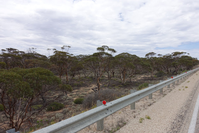
The nullarbor is the world's largest limestone plain landscape, covering 270,000 square kilometres -- the SA section alone is about the size of Tasmania, and that's only one-third of it, with the majority is on the Western Australian side. Most people are aware of the latin roots of the name 'nullarbor' meaning 'no trees' but there are popular misconceptions about this 'Australian icon' and scene for your quintessential Aussie pilgrimage. While it evokes scenes of thousands of kilometres of nothing, the truth is the Eyre Highway between Norseman to the west and Ceduna to the east is 1,200 km of landscape that varies from mallee forest with red soil to myall acacia open woodlands to heathland to the treeless plain around the Nullarbor roadhouse (a stretch of 20 km of highway with only low saltbush (Atriplex spp), bluebush (Marieana or Bassia spp) or stunted wind-shaped Eucalypts hardly recognisable as gum trees at all) to salmon gums in salmon-coloured dirt to sheep pasture and wheat fields.
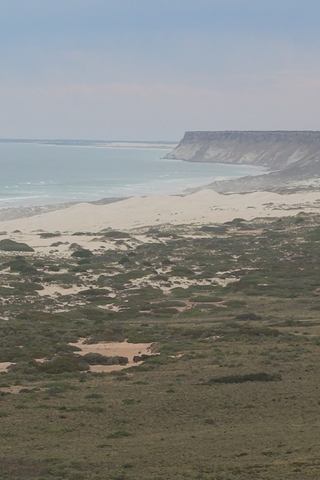
The bluebush and saltbush characteristic of the plains around Nullarbor and Madura are highly adapted arid species that can actually get water from the air through their leaves. With a slow cycle across the Nullarbor you notice the diversity of flora, including the threatened species of Eremophila, the Nullarbor emu bush which has grey furry leaves similar to saltbush. There is also plenty of sandlewood and also some rare clusters of quandong which were in fruit. Underneath the plain there are about 250 limestone caves, of which unusual fauna inhabit. The scenery on offer also include the spectacular cliffs over the southern ocean, up to 75 metres high with chocolate brown tops and white below like some kind of delicious two tone lamington of limestone, towering above the brilliantly blue water which pounds on the coastline to take more of Southern Australia away along with the southerly wind. There are stunning views along the ragged coastline for 200 km at a time on the southern edge of Australia's mainland. There are places where there is a cliff set in from the edge, where a higher water level eroded this cliff face at another epoch. Around Eucla you even find brilliant white sandhills, which you can spot in the distance as you climb Eucla pass.
Under the expansive nullarbor plain there is an underground water system where the ocean may reach as far as hundreds of kilometres inland, making itself known as blowholes where you'd not expect them, and some of the caves have clear water at their base. Surface water is extremely scarce. Norseman gets its water from Perth via pipeline. West from there the water is sourced from bores down to the underground water table and requires desalination to drink. Only during wet times do the dolines (circular depressions, or sometimes holes down to caves) and rock holes contain water, and even then it evaporates quickly unless shaded by vegetation. There are no towns between Norseman and Ceduna, only roadhouses to service travellers and residents with fuel and meals. On the Western Australia side there are two rain shed fed water tanks to assist the bicycle traveller, if you are lucky enough they may have some water in them. The SA side does not seem to have any tank available.
The plain itself is ancient sea bed, having raised from the sea 3 million years ago. Curiously, as you travel along you can sometimes see shells in the roadbase shoulder next to the road, and when you are close to the coastline you can see shells amongst the bushes, even though you are 60 metres above the ocean.
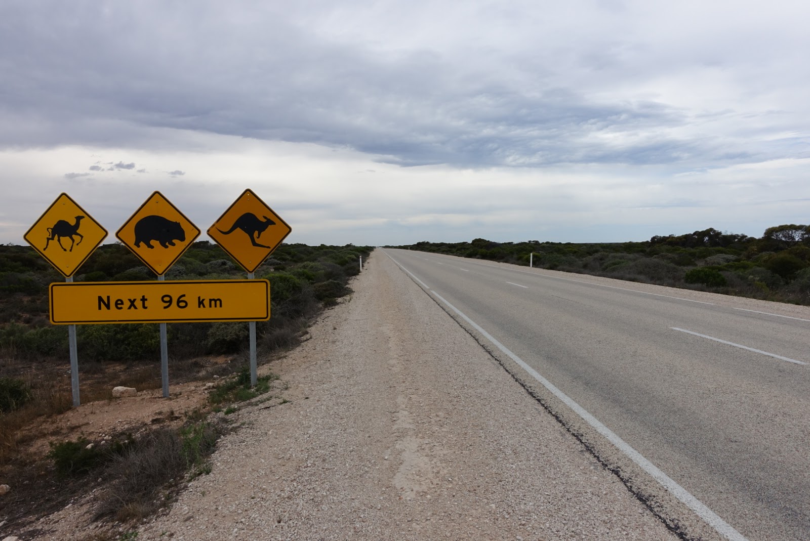
Some of the wildlife along this stretch of Australia include kangaroos, (Australia's largest populations of) southern hairy-nosed wombats, dingoes, 86 reptile species including the Nullarbor bearded dragon (and we had a few blue tongues poked out of bobtails), and one lonely frog species, all joined by pests such as camels (saw one carcus), wild dogs, foxes, feral cats (saw one 'Nullarbor puma' that was a kitten) and thousands of rabbits. Along the coast you might see whales (in great numbers, Southern right whales give birth near the head of the bight between May and October), seals and albatross.
Birdlife includes wedgetails working in pairs to hunt down emu, mallee fowls, galahs (we noticed one of the pair was a deeper pink than the other), major mitchell cockatoos, the endemic Nullarbor quail thrush, plains wanderers, Naretha blue bonnets, ospreys, white-bellied sea eagles, peregrine falcons, kestrels (saw many of these), sandpipers (we saw one looking for grub on a road shoulder?), tawny frogmouths (saw one dead one, crushed on the road shoulder where it was probably sunning), a hundred tuneful brown song larks, and rainbow bee eaters (a couple darted in front of me near Balladonia, quite possibly in pursuit of bees). I was disappointed to not see any flocks of budgies.
The stretch of highway along the Nullarbor is littered with broken down cars of various decades either rolled or smashed or simply ran-out-of-fuel and stripped of parts before they got more fuel.
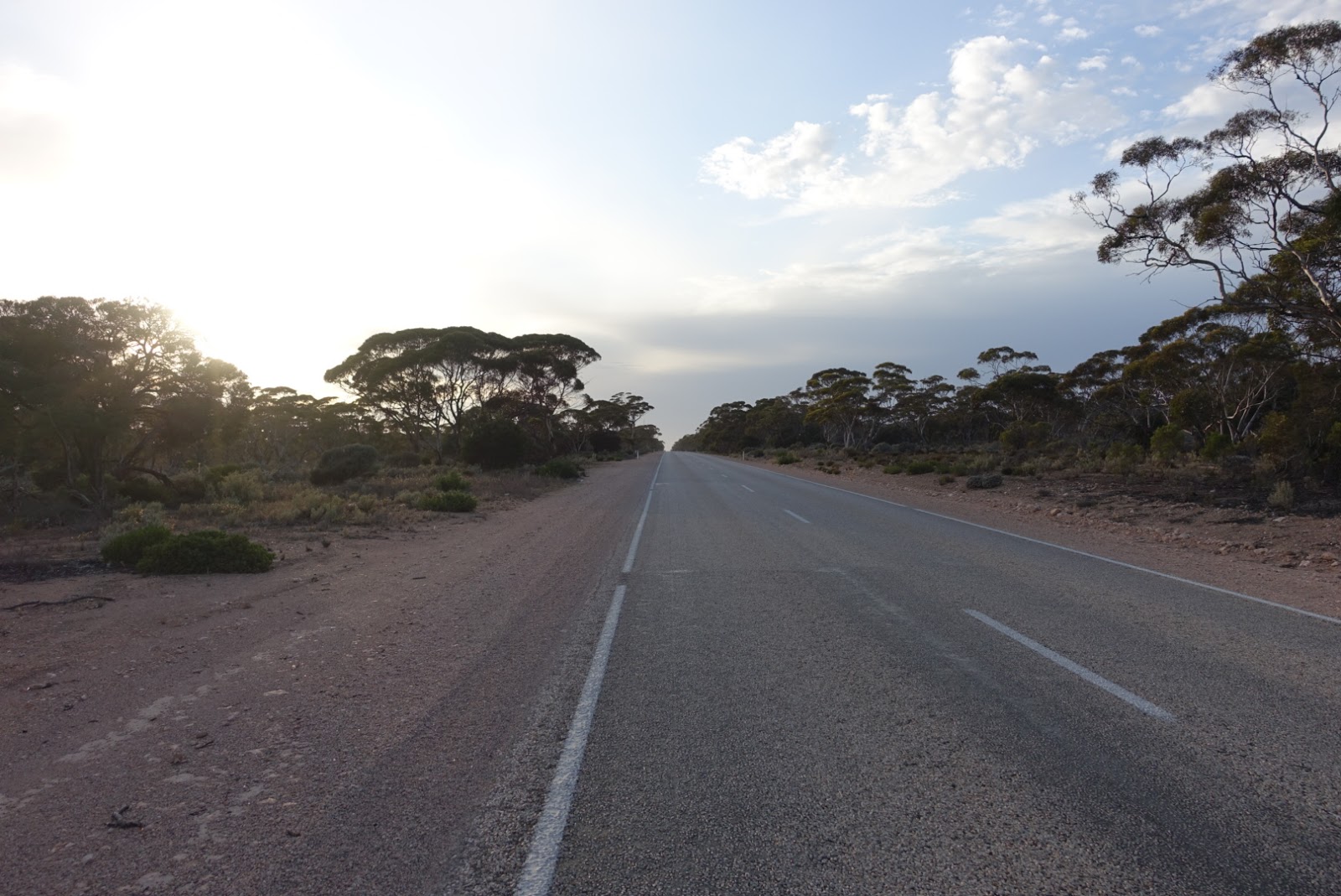
As we crossed the nullarbor over a period of ten days, we saw electrical storms and rain in the mallee before Balladonia, putting precious water in the tanks ahead of us. We camped in a quagmire of mud on the first night, 120 km from Norseman because we couldn't find a site more suitable before dark. We made it to Balladonia roadhouse for lunch with the Melbourne Cup horse rangling showing on the TV (the burger was delicious) and then rode another 150 km day to camp in some bush on the 90 mile straight (At 146.6 km long, Australia's longest straight road). Another roadhouse burger at Caiguna (also delicious), and then the lovely ride out of Caiguna with white limestone rocks sprinkled in chenopod shrubland and scattered mallee. We found a lovely isolated camp up a track, within riding distance in the morning for breakfast at Cocklebiddy, and no clouds finally so we could see the outback stars and make before dawn for the planet and crescent moon alignment to the east. Next night was 5 km from Madura. The following a camp beside a range similar to the Madura camp, after riding 100 km into a headwind that ranged between 30 km/h and 50 km/h. The camp was just across the road from the rain shed (which had water in it, yay) and 5 km from Mundrabilla roadhouse where we had breakfast the next morning. We climb up Eucla Pass and cross over the border and onto South Australia's shitty version of highway 1 which lacks a road shoulder despite the oversize traffic. Now we are close to the Bunda Cliffs so we duck down tracks every now and then to have a glimpse, and click over 9000 km doing so. We camp amongst some shells and shrubs about 600 metres from the edge as the sky grows dark with a storm that never reaches us. Next day we ride to about 30 km from Nullarbor roadhouse, just before the treeless plain starts. Breakfast at the roadhouse the next day, but not until after we have a coin operated $1 shower - the first shower in a thousand kilometres and well enjoyed - and wash our disgusting clothes. For another $1 coin we filled up our bottles with desalinated water from the coin-operated tap there. After the treeless plain ends and trees start appearing again, you've got your last "typical nullarbor vegetation" before it goes back to mallee sitting in salmon dirt around Yalata. We were riding the hills around here on a day that got to 38 degrees in the shade around 2pm, where we decided to get off the road and sit in the shade for an hour and not bake. We camped on the edge of an abandoned farm (with limestone brick farmhouse ruins in the background) before riding 30 km into Nundroo the next day. There was a roadhouse at Yalata but there is a sad story of how it was shut down because of structural issues with the building and has never been replaced due to lack of funds, despite the good it brought to the community and to travellers. Now the country is wheat and sheep farms as far as the eye can see. And we have a 50 km/h sidewind/headwind to content with all day, limiting our distance to 100 km. Another night camping in remnant scrub, and within ride-to-breakfast-distance to Penong, and then the last 71 km stretch into Ceduna, where we arrived for check-in time to a motel. I think the most tiresome thing was attempting to share the road with oversize vehicles when there was no safe shoulder. If South Australia/Federal infrastructure payed for a sealed shoulder on this SA side of highway 1 everyone would be able to get along a lot better and the roads would be safer for it. As it is, you have to get off onto the shoulder at a slow speed and at a certain angle otherwise you simply cannot keep the bike upright, and because the road has no buffer and a lot of oversize vehicles and large caravans on it, you have to be ever vigilant with mirrors and whats coming up to keep safe, which is heroically tiring. But nothing has changed in the four years since I travelled this way last, so I'm not holding my breath.


I'll be updating my Nullarbor advice page with errata and new things I picked up this time shortly.
The sun is starting to set as we ride out of Madura roadhouse towards my "secret spot" to camp 5 km down the road. There is no rush, so we dawdle along stopping to take photos of the brilliant display of blue bush in front of the Madura Pass range. Just at the sign on the other side of the road that says 5 km to Madura, I duck down a track that leads to a low, wire fence without any barbs. We wait for no traffic and get our bikes and gear over the fence to hide behind shrubs, emerging only to take photos of the sky's dying light. There is this unremarkable dead tree here that comes back to life as the star of pictures, its silhouette contrast against the bright sunset colours. We make camp as the birds twitter their evening gossip and flitter amongst the shrubbery.


Earlier this day we descended the Madura Pass which is a steep descent down the side of the Madura shelf, overlooking the Roe Plains dotted with shrubs, to drop down to that level. The road has not a safe shoulder, being narrow and eroded -- if you left the asphalt you'd hit some rubble and kiss the gravel -- so you just hope you've been lucky enough to time it so no truck or caravan is going to try zooming past you at the same time. After the exhilarating descent we visited the bar at Madura for a calming beverage and hung about for some dinner.
Six days earlier we left Kalgoorlie-Boulder to ride the 190 km to Norseman, chased by storms that threatened to break on us, but didn't manage it, only sending us a handful of heavy raindrops to let it know who was boss. We clicked over 8000 km just as we left Kalgoorlie. One night we camped in the fly-ridden mallee of a remnant bush reserve south of Kambalda nestled in amongst all the mines, and the next, a fly-ridden recently burnt section of scrub 30 km out of Norseman. We headed into Norseman early on Monday morning to fill up all our water bottles and stock up on food for the trip across the Nullarbor Plain.
The nullarbor is the world's largest limestone plain landscape, covering 270,000 square kilometres -- the SA section alone is about the size of Tasmania, and that's only one-third of it, with the majority is on the Western Australian side. Most people are aware of the latin roots of the name 'nullarbor' meaning 'no trees' but there are popular misconceptions about this 'Australian icon' and scene for your quintessential Aussie pilgrimage. While it evokes scenes of thousands of kilometres of nothing, the truth is the Eyre Highway between Norseman to the west and Ceduna to the east is 1,200 km of landscape that varies from mallee forest with red soil to myall acacia open woodlands to heathland to the treeless plain around the Nullarbor roadhouse (a stretch of 20 km of highway with only low saltbush (Atriplex spp), bluebush (Marieana or Bassia spp) or stunted wind-shaped Eucalypts hardly recognisable as gum trees at all) to salmon gums in salmon-coloured dirt to sheep pasture and wheat fields.
The bluebush and saltbush characteristic of the plains around Nullarbor and Madura are highly adapted arid species that can actually get water from the air through their leaves. With a slow cycle across the Nullarbor you notice the diversity of flora, including the threatened species of Eremophila, the Nullarbor emu bush which has grey furry leaves similar to saltbush. There is also plenty of sandlewood and also some rare clusters of quandong which were in fruit. Underneath the plain there are about 250 limestone caves, of which unusual fauna inhabit. The scenery on offer also include the spectacular cliffs over the southern ocean, up to 75 metres high with chocolate brown tops and white below like some kind of delicious two tone lamington of limestone, towering above the brilliantly blue water which pounds on the coastline to take more of Southern Australia away along with the southerly wind. There are stunning views along the ragged coastline for 200 km at a time on the southern edge of Australia's mainland. There are places where there is a cliff set in from the edge, where a higher water level eroded this cliff face at another epoch. Around Eucla you even find brilliant white sandhills, which you can spot in the distance as you climb Eucla pass.
Under the expansive nullarbor plain there is an underground water system where the ocean may reach as far as hundreds of kilometres inland, making itself known as blowholes where you'd not expect them, and some of the caves have clear water at their base. Surface water is extremely scarce. Norseman gets its water from Perth via pipeline. West from there the water is sourced from bores down to the underground water table and requires desalination to drink. Only during wet times do the dolines (circular depressions, or sometimes holes down to caves) and rock holes contain water, and even then it evaporates quickly unless shaded by vegetation. There are no towns between Norseman and Ceduna, only roadhouses to service travellers and residents with fuel and meals. On the Western Australia side there are two rain shed fed water tanks to assist the bicycle traveller, if you are lucky enough they may have some water in them. The SA side does not seem to have any tank available.
The plain itself is ancient sea bed, having raised from the sea 3 million years ago. Curiously, as you travel along you can sometimes see shells in the roadbase shoulder next to the road, and when you are close to the coastline you can see shells amongst the bushes, even though you are 60 metres above the ocean.
Some of the wildlife along this stretch of Australia include kangaroos, (Australia's largest populations of) southern hairy-nosed wombats, dingoes, 86 reptile species including the Nullarbor bearded dragon (and we had a few blue tongues poked out of bobtails), and one lonely frog species, all joined by pests such as camels (saw one carcus), wild dogs, foxes, feral cats (saw one 'Nullarbor puma' that was a kitten) and thousands of rabbits. Along the coast you might see whales (in great numbers, Southern right whales give birth near the head of the bight between May and October), seals and albatross.
Birdlife includes wedgetails working in pairs to hunt down emu, mallee fowls, galahs (we noticed one of the pair was a deeper pink than the other), major mitchell cockatoos, the endemic Nullarbor quail thrush, plains wanderers, Naretha blue bonnets, ospreys, white-bellied sea eagles, peregrine falcons, kestrels (saw many of these), sandpipers (we saw one looking for grub on a road shoulder?), tawny frogmouths (saw one dead one, crushed on the road shoulder where it was probably sunning), a hundred tuneful brown song larks, and rainbow bee eaters (a couple darted in front of me near Balladonia, quite possibly in pursuit of bees). I was disappointed to not see any flocks of budgies.
The stretch of highway along the Nullarbor is littered with broken down cars of various decades either rolled or smashed or simply ran-out-of-fuel and stripped of parts before they got more fuel.
As we crossed the nullarbor over a period of ten days, we saw electrical storms and rain in the mallee before Balladonia, putting precious water in the tanks ahead of us. We camped in a quagmire of mud on the first night, 120 km from Norseman because we couldn't find a site more suitable before dark. We made it to Balladonia roadhouse for lunch with the Melbourne Cup horse rangling showing on the TV (the burger was delicious) and then rode another 150 km day to camp in some bush on the 90 mile straight (At 146.6 km long, Australia's longest straight road). Another roadhouse burger at Caiguna (also delicious), and then the lovely ride out of Caiguna with white limestone rocks sprinkled in chenopod shrubland and scattered mallee. We found a lovely isolated camp up a track, within riding distance in the morning for breakfast at Cocklebiddy, and no clouds finally so we could see the outback stars and make before dawn for the planet and crescent moon alignment to the east. Next night was 5 km from Madura. The following a camp beside a range similar to the Madura camp, after riding 100 km into a headwind that ranged between 30 km/h and 50 km/h. The camp was just across the road from the rain shed (which had water in it, yay) and 5 km from Mundrabilla roadhouse where we had breakfast the next morning. We climb up Eucla Pass and cross over the border and onto South Australia's shitty version of highway 1 which lacks a road shoulder despite the oversize traffic. Now we are close to the Bunda Cliffs so we duck down tracks every now and then to have a glimpse, and click over 9000 km doing so. We camp amongst some shells and shrubs about 600 metres from the edge as the sky grows dark with a storm that never reaches us. Next day we ride to about 30 km from Nullarbor roadhouse, just before the treeless plain starts. Breakfast at the roadhouse the next day, but not until after we have a coin operated $1 shower - the first shower in a thousand kilometres and well enjoyed - and wash our disgusting clothes. For another $1 coin we filled up our bottles with desalinated water from the coin-operated tap there. After the treeless plain ends and trees start appearing again, you've got your last "typical nullarbor vegetation" before it goes back to mallee sitting in salmon dirt around Yalata. We were riding the hills around here on a day that got to 38 degrees in the shade around 2pm, where we decided to get off the road and sit in the shade for an hour and not bake. We camped on the edge of an abandoned farm (with limestone brick farmhouse ruins in the background) before riding 30 km into Nundroo the next day. There was a roadhouse at Yalata but there is a sad story of how it was shut down because of structural issues with the building and has never been replaced due to lack of funds, despite the good it brought to the community and to travellers. Now the country is wheat and sheep farms as far as the eye can see. And we have a 50 km/h sidewind/headwind to content with all day, limiting our distance to 100 km. Another night camping in remnant scrub, and within ride-to-breakfast-distance to Penong, and then the last 71 km stretch into Ceduna, where we arrived for check-in time to a motel. I think the most tiresome thing was attempting to share the road with oversize vehicles when there was no safe shoulder. If South Australia/Federal infrastructure payed for a sealed shoulder on this SA side of highway 1 everyone would be able to get along a lot better and the roads would be safer for it. As it is, you have to get off onto the shoulder at a slow speed and at a certain angle otherwise you simply cannot keep the bike upright, and because the road has no buffer and a lot of oversize vehicles and large caravans on it, you have to be ever vigilant with mirrors and whats coming up to keep safe, which is heroically tiring. But nothing has changed in the four years since I travelled this way last, so I'm not holding my breath.


 |
| Madura Pass |


I'll be updating my Nullarbor advice page with errata and new things I picked up this time shortly.
Subscribe to:
Posts (Atom)