
This is a summary of the 10 day tour in Kelly Country which was about 700 km including side trips and pottering around towns.

Thursday 24th December 2009
Caught a v-line train from Southern Cross station to Seymour station after work.
Camped at Seymour caravan park overnight.
Investigated the Goulburn River in the evening.
Friday 25th December 2009
Was offered xmas breakfast and then xmas lunch before leaving the caravan park but had to decline both.
Rode 64 km from Seymour to Euroa, mostly on the "old Hume Hwy"
Camped at Euroa overnight in caravan park.
Saturday 26th December 2009
Rode 77 km from Euroa to Glenrowan, temperatures up to 39 degrees through Winton and Glenrowan.
Saw an echidna up close and personal.
Camped overnight at Glenrowan caravan park.
Sunday 27th December 2009
Had breakfast in Glenrowan (in the park) where I met Paul from Wangaratta who offered a place to sleep and dinner if I was stopping in Wangaratta.
Had planned to ride to Warby Range National park camping area but the heat decided against this.
Rode 49 km Glenrowan to Everton via Wangaratta, on the Murray to Mountains rail trail from Wangaratta. Made it to Everton around 2pm. Another hot day so couldn't make it to Beechworth as I had aimed to do (16 km uphill from Everton).
Man running the Everton caravan park gave me a voucher for free coffee when I made it to Beechworth.
Monday 28th December 2009
Another day riding on the Murray to Mountains rail trail.
Got away early for once at 7am (the trick in this heat is to get away early).
Rode 16 km uphill Everton to Beechworth in 2 hours.
Flew 16 km downhill from Beechworth to Everton in 45 minutes.
Rode 28 km Everton to Myrtleford (very hot 42 degrees, no water in Taylors Gap water tank!)
Camped overnight at Arden's caravan park.
Met John and Eve from Goulbourn Island (NT) who are planning to ride the UK.
Chatted with John for at least an hour that night.
Tuesday 29th December 2009
Rode 68 km Myrtleford to Bright and back to Myrtleford by 11.30 am.
Too hot 32 degrees in the shade, so called it a day and camped again at Ardens.
Had dinner with John and Eve and a long chat.
Left them with my blog url and mobile number.
Wednesday 30th December 2009
Rode 41 km to Moyhu by 11 am.
Camped overnight at Moyhu.
Used the swimming pool to recover in the heat.
Thursday 31 December 2009
Rode 47 km to Benalla.
Visited the Benalla art gallery where they had an exhibition of the works of Dean Bowen who is now one of my favourites.
Camped overnight at Benalla caravan park.
Watched the third Lord of the Rings on the big screen TV in the camp kitchen.
Met Harry who cycled the Darling River and made it about half way around Australia once before falling ill. Swapped email addresses.
Thunderstorm overnight with very strong winds and heavy rainfall, rain soaked through the seams of my bivvy bag so I lay in a puddle all night. Luckily it wasn't cold.
Friday 1st January 2010
Rode 101 km to Nagambie as it was a cooler day (about 32 degrees). Got to Nagambie by 4 pm despite resting at Euroa in a park for 1 hour and a half.
Camped overnight at Nagambie caravan park (not the one on the lake).
Saturday 2nd January 2010
Rest day in Nagambie.
Bored as hell. Waterskiing thing was happening on the lake. Zzzz. Hang around in another park watching people catch fish. Visited the museum. Saw three old bikes from the 1800s there amongst the agricultural machinery relics.
Sunday 3rd January 2010
Rode 48 km to Seymour in headwinds.
Caught train back to Melbourne.
Wildlife tally
- 3 echidnas, 1 roadkill echidna (Hume Hwy)
- 3 wedgetail eagles
- 1 goanna
- 7 kangaroos
- 2 roadkill turtles
- 1 million billion gallahs
- 1 million rabbits
- 1 redback spider
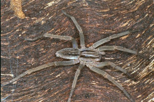
- 1 Miturga lineata Prowling spider
- 1 hare
- 0 koalas
- 0 snakes
Equipment failures
- The Surly LHT held up awesome to the battering I gave it. Washboard roads on three days, unsealed gravel or dirt roads most days, even unused bush tracks, big hills, fast corners... I felt in control in all but the most gravelly of shoulders and by the end of the tour the bike felt like I was riding an unloaded bicycle. I needed to push my bike up only four hills (I saw plenty).
- Topeak handlebar bag from the 'DryBag' series (this one) - sealed seams came apart after 2 days of use, not doing anything but carrying a map and a camera. Very disappointing. Will try to replace with either Topeak Tourguide Handlebar bag or another brand, maybe Ortlieb.
- On day two of riding a stick got stuck in between wheel and front fender and fender came off the struts. Easy to fix.
- Zero punctures (Continental Contacts)
- Tent leaks in bad weather so need to ensure I use a fly over the top to minimise the risk.
- Tent pegs bend easily in hard ground and don't stay in during windy weather.
- Despite the bad weather on two nights, ortlieb panniers remained waterproof.
- Lost one QL2 anchoring hook from one of the rear ortlieb panniers - probably my fault not making it tight enough on adjustment.
- Sometimes I put the trangia burners lid on too tight and I can't get it off for half an hour.
Body failures
- No real issues. Neck was a little stiff after riding on day one. Some minor saddle soreness, minor hand soreness between thumb and forefinger.
- Found it difficult on the really hot (35 degrees or more) days to do more than 40 km (or ride after 2pm) without feeling crappy.
Potential wild camping spots
- Goulburn River, Seymour - on the multipurpose trail near the old hume highway wooden trestle bridge.
- River Street Reserve at Nagambie - has toilet facilities.
Decent facilities
- Wangaratta toilet block near the start of the rail trail (before you go over the bridge) has a "family room" with electricity and hot water boiler.
- Longwood "Pub Paddock" has water, toilets, shelter and electricity.
Useful information
I picked up a free map called "Driver's Guide to Rural Victoria" which describes the different types of roads based on their "number". e.g. a road might be B100 (Great Ocean Road) and the B actually means something.
- 'M' roads are duplicated highways (has median strip in the middle) - primary links between cities and major centres. Divided carriageways, foure traffic lanes, sealed shoulders, linemarkings
- 'A' roads are same as M except carry less traffic. Single carriageways. Shoulder sealing will be provided soon if it hasn't been already.
- 'B' roads are links between tourist regions not served by A roads. Sealed pavements, two traffic lanes, good linemarking and shoulders.
- 'C' roads are links between other centres. Usually two lanes sealed roads with dirt/gravel shoulders.
I thought the shoulder information was useful as a touring cyclist who enjoys a good bitumen shoulder for safety and comfort. :)
There is also a somewhat amusing log of the trip.
No comments:
Post a Comment